
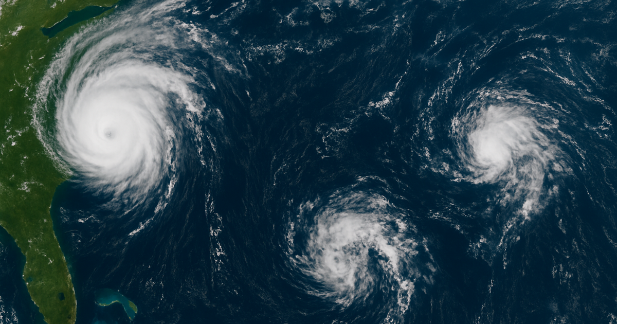
Hurricane Erin is finally making its exit after days of stirring up the Atlantic, but the tropics aren’t taking a break just yet. As Erin drifts away into open waters, fresh systems are bubbling up—reminding us that hurricane season is far from over.
Erin’s Long Goodbye
Erin never made a direct landfall in the U.S., but its presence was still felt up and down the East Coast. The storm’s sheer size—stretching more than 500 miles across—pushed powerful waves onto beaches from the Carolinas to New England. Some ferry services were halted, coastal roads flooded, and beach dunes took a beating from relentless surf.
At its peak, Erin roared to life as a Category 5 hurricane, strengthening at an almost unbelievable pace. Meteorologists called it one of the fastest intensifying storms on record, fueled by unusually warm ocean waters. While the storm has now lost its tropical punch and is sliding northeast into cooler seas, its rapid rise was another warning sign of how quickly conditions can change in today’s climate.
Fresh Trouble in the Tropics
Just as Erin exits stage right, meteorologists already have their eyes on new players in the Atlantic.
- Invest 90L: This system, swirling a few hundred miles northeast of the Leeward Islands, is showing strong signs of development. The National Hurricane Center says it has a high chance of becoming the season’s next named storm—possibly Tropical Storm Fernand. Current models suggest it could curve northward, posing more of a risk to Bermuda than the U.S. East Coast.
- Invest 99L: Further east, another system is struggling to organize as it drifts across the Atlantic. While its chances are lower, forecasters say it could briefly spin up into a tropical depression.
Together, these systems show the Atlantic is heating up right on cue. Late August through mid-September is traditionally the most active stretch of hurricane season, and this year looks no different.
Why It Matters
Erin’s story highlights a bigger trend: storms are getting bigger, faster, and harder to predict. For coastal communities, that means preparation needs to start earlier—and people shouldn’t let their guard down just because one storm moves away.
Bermuda and other Atlantic islands will be watching Invest 90L closely in the coming days, while U.S. residents are advised to keep checking updates. Hurricane season peaks around September 10, so the weeks ahead could bring more surprises.
The Bottom Line
Erin may be fading into the distance, but the Atlantic is far from quiet. With at least two new systems developing, the tropics are reminding us that hurricane season is only getting started.
Stay tuned, stay prepared, and don’t let Erin’s exit fool you—the show isn’t over yet.
Also Read: Texas Senate Just Passed a New Republican-Drawn Congressional Map – And It’s Stirring Up a Storm!
Visit: Maxima Sale

Hey I am Srimanta Pradhan brings 10 years of experience to News Broadcast and Marketing, specializing in effective communication.A specialized content writer with a decade of expertise crafting compelling narratives for News Broadcast and Marketing. Transforms complex information into engaging, impactful content.


